


-
-
Home
-
About District
Introduction to the District
History-Tradition
Others
-
Administration
Deputy Commissioner
DDLG/ADC
Officers & Staffs
-
Govt. Offices
Security & Discipline Affairs
Education & Culture
Agriculture, Fish, Livestock and Agriculture
-
Agriculture Extension Office, Lalmonirhat
-
District Fisheries Office
-
District Livestock Office
-
District Food Office
-
District BADC Office
-
District Agriculture Marketing Office
-
District BADC (IR) Office
-
District Seed Certification Office
-
District Jute Development Office
-
Spice Research Sub-Center
-
Institute of Livestock Science and Technology (ILST), Kaliganj, Lalmonirhat
-
BMDA, Lalmonirhat
-
Bangladesh Food Safety Authority, Lalmonirhat
-
Soil Resource Development Institute, Lalmonirhat
Health & Environment
Engineering & ICT
-
Local Govt Engineering Dept, Lalmonirhat
-
Public Health Engineering Dept, Lalmonirhat
-
Education Engineering Dept, Lalmonirhat
-
District Office, Department of ICT
-
Health Engineering Department (HED), Lalmonirhat
-
District Relief & Rehabilitation Office
-
Palli Bidyut Somiti, Lalmonirhat Zonal Office
-
District Information Office
-
Roads and Highways Division, Lalmonirhat
-
Public Works Department, Lalmonirhat
-
District Water Development Board Office
-
District BTCL Office
-
District Electricity Development Board Office
Human Resources
-
District Social Services Office
-
District Youth Development Office
-
District Cooperative Office
-
District Women affairs Department
-
Bangladesh Rural Development Board, Lalmonirhat
-
District PalliDaridro Bimicon Foundation Office
-
District Islamic Foundation Office
-
Jatiyo Mahila Songstha, District Office, Lalmonirhat
-
Palli Sanchay Bank, Lalmonirhat
-
Sarkari Shishu Paribar (Girls\'), Lalmonirhat
-
Govt. Technical Training Center (TTC), Lalmonirhat
-
Labour Welfare Center, Lalmonirhat
Land & Revenue
Other Offices
-
District Statistics Office
-
District Accounts and Finance Office
-
District Election Office
-
District National Consumer Rights Protection Office
-
District Regional Passport Office
-
District BRTA Office
-
District Small and Cottage Industries Corporation Office
-
District Post Office
-
Bangladesh Railway, Lalmonirhat
-
Bangladesh House Building Finance Corporation
-
Agriculture Extension Office, Lalmonirhat
-
Local Government
District Council
Lalmonirhat Municipality
Patgram Municipality
Upazila Councils
Union Councils
- E-Service Centre
- Gallery
- July Revolution Gallery
-
-
Home
-
About District
Introduction to the District
History-Tradition
Others
-
Administration
Deputy Commissioner
DDLG/ADC
Officers & Staffs
-
Govt. Offices
Security & Discipline Affairs
Education & Culture
Agriculture, Fish, Livestock and Agriculture
- Agriculture Extension Office, Lalmonirhat
- District Fisheries Office
- District Livestock Office
- District Food Office
- District BADC Office
- District Agriculture Marketing Office
- District BADC (IR) Office
- District Seed Certification Office
- District Jute Development Office
- Spice Research Sub-Center
- Institute of Livestock Science and Technology (ILST), Kaliganj, Lalmonirhat
- BMDA, Lalmonirhat
- Bangladesh Food Safety Authority, Lalmonirhat
- Soil Resource Development Institute, Lalmonirhat
Health & Environment
Engineering & ICT
- Local Govt Engineering Dept, Lalmonirhat
- Public Health Engineering Dept, Lalmonirhat
- Education Engineering Dept, Lalmonirhat
- District Office, Department of ICT
- Health Engineering Department (HED), Lalmonirhat
- District Relief & Rehabilitation Office
- Palli Bidyut Somiti, Lalmonirhat Zonal Office
- District Information Office
- Roads and Highways Division, Lalmonirhat
- Public Works Department, Lalmonirhat
- District Water Development Board Office
- District BTCL Office
- District Electricity Development Board Office
Human Resources
- District Social Services Office
- District Youth Development Office
- District Cooperative Office
- District Women affairs Department
- Bangladesh Rural Development Board, Lalmonirhat
- District PalliDaridro Bimicon Foundation Office
- District Islamic Foundation Office
- Jatiyo Mahila Songstha, District Office, Lalmonirhat
- Palli Sanchay Bank, Lalmonirhat
- Sarkari Shishu Paribar (Girls\'), Lalmonirhat
- Govt. Technical Training Center (TTC), Lalmonirhat
- Labour Welfare Center, Lalmonirhat
Land & Revenue
Other Offices
- District Statistics Office
- District Accounts and Finance Office
- District Election Office
- District National Consumer Rights Protection Office
- District Regional Passport Office
- District BRTA Office
- District Small and Cottage Industries Corporation Office
- District Post Office
- Bangladesh Railway, Lalmonirhat
- Bangladesh House Building Finance Corporation
-
Local Government
District Council
Lalmonirhat Municipality
Patgram Municipality
Upazila Councils
Union Councils
- E-Service Centre
-
Gallery
Photo Gallery
Video Gallery
-
July Revolution Gallery
List of Heroic Martyrs
List of Injured
Memories of the July Revolution
Graffiti Gallery
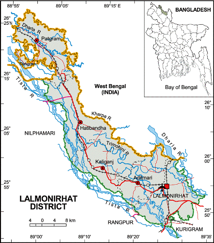
Size: 1241.46 sq km Location: 25 ° 46' to 26 ° 33'N north latitudes and 89 ° 01'E 89 ° 36 'east longitude. Boundary: West Bengal state of India, Rangpur district on the south, Kurigram and West Bengal state of India on the east, Nilphamari and Rangpur districts on the west. Lalmonirhat can be called an enclave district. There are 33 enclaves in this district. The two largest enclaves in the district are Dahagram and Angarpota. These two enclaves have been arranged with the mainland through three bigha corridors.


Planning and Implementation: Cabinet Division, A2I, BCC, DoICT and BASIS
Technical Assistance:
![]()
Developed By:
